
Tectonic Plates: The Moving Puzzle Beneath Our Feet
At first glance, Earth’s surface appears solid, stable, and unchanging. Mountains seem eternal, and continents and oceans appear to occupy the same places forever. Yet beneath this calm appearance lies a restless planet, shaped by deep forces that act continuously.
The theory of plate tectonics — now one of the pillars of geology — revealed that Earth’s crust is dynamic, fragmented, and constantly transforming. This discovery revolutionized the way we understand earthquakes, volcanoes, mountain ranges, and even the distribution of continents.
Understanding this mechanism is not merely a scientific curiosity; it directly influences how societies prepare for natural disasters, how they explore mineral and energy resources, and how they interpret the planet’s long and complex geological history. Tectonic plates are, in essence, the engine that keeps Earth alive.
Plate Tectonics Theory: From Intuition to Scientific Model
The journey toward the modern theory began with a simple yet deeply intriguing observation: the shape of the continents. In 1912, German meteorologist Alfred Wegener noticed that the east coast of South America seemed to fit perfectly against the west coast of Africa. He proposed the theory of continental drift, suggesting that the continents had once formed a supercontinent — Pangaea — and that over time they had drifted apart.
The idea was bold, but it lacked a crucial element: a mechanism. Wegener could not explain what force could move such massive landmasses. As a result, his theory was widely rejected by the scientific community at the time.
The situation began to change decades later as ocean exploration advanced significantly. During and after World War II, ships equipped with sonar mapped the ocean floor and revealed surprising structures: underwater mountain ranges such as the Mid-Atlantic Ridge and deep trenches like the Mariana Trench.
These discoveries showed that the ocean floor was not static but it was being continuously created and destroyed.
In the 1960s, a series of independent lines of evidence converged on the same conclusion. Symmetrical magnetic patterns in oceanic rocks demonstrated that the seafloor was spreading. Global records of earthquakes revealed lines of seismic activity that coincided with boundaries between large crustal blocks. The sum of these observations led to the birth of Plate Tectonics Theory, which finally explained continental movement and unified diverse geological phenomena into a single coherent model.
Earth in Motion: Understanding Tectonic Plates
Earth’s outer layer, called the lithosphere, is divided into large rigid blocks known as tectonic plates. Each plate includes Earth’s crust (continental or oceanic) and the uppermost portion of the mantle. Beneath them lies the asthenosphere, a hot and partially plastic layer that allows the plates to slide.
These plates move slowly, just a few centimeters per year, driven by Earth’s internal heat. Convection currents in the mantle, gravity, and the density of oceanic rocks all contribute to this continuous motion. Although imperceptible in daily life, this displacement reshapes Earth’s surface over millions of years.
The composition of plates varies depending on their nature:
- Oceanic plates: Formed by dense basaltic rocks, created at mid-ocean ridges.
- Continental plates: Composed of lighter, thicker granitic rocks.
- Mixed plates: Contain both oceanic and continental crust, making their interactions more complex.
This diversity of materials explains why some plates sink beneath others, why continents remain elevated, and why certain regions are more prone to earthquakes and volcanoes.
Plate Boundaries: Where Earth Reveals its Power
Most geological activity occurs at plate boundaries, where plates interact in three main ways:
Divergent Boundaries
Plates move apart, allowing magma to rise and form new crust. A classic example is the Mid-Atlantic Ridge, where the Atlantic Ocean continues to widen slowly.
Convergent Boundaries
Plates collide, and depending on their composition, two main scenarios can occur:
Subduction: An oceanic plate sinks beneath another plate (oceanic or continental), resulting in volcanoes, ocean trenches, and deep earthquakes.
Continental Collision: Two continental plates crash into each other and fold, resulting in the formation of massive mountain ranges such as the Himalayas.
Transform Boundaries
Plates slide laterally past one another. Example: the San Andreas Fault in California, famous for generating frequent earthquakes and one of the most studied transform boundaries in the world.
These interactions shape Earth’s landscape and explain why certain regions are geologically so active.
The Global Mosaic: Where Tectonic Plates are Located
Earth is divided into several major plates, including:
- Pacific Plate – largest oceanic plate, responsible for much of the seismic activity around the Ring of Fire.
- North American Plate – covers North America, parts of the Atlantic Ocean, and parts of Siberia.
- Eurasian Plate – spans Europe and most of Asia.
- African Plate – includes continental Africa and surrounding oceanic crust.
- South American Plate – covers South America and part of the western Atlantic Ocean.
- Antarctic Plate – encompasses Antarctica and surrounding ocean floor.
- Indo-Australian Plate – sometimes divided into Indian Plate and Australian Plate; covers India, Australia, and adjacent oceanic crust.
In addition, there are smaller but extremely important plates:
- Nazca Plate – oceanic plate off the west coast of South America, subducting beneath the South American Plate.
- Cocos Plate – smaller oceanic plate off Central America.
- Caribbean Plate – includes the Caribbean Sea and parts of Central America.
- Scotia Plate – near the southern Atlantic, between South America and Antarctica.
- Arabian Plate – covers the Arabian Peninsula.
- Philippine Sea Plate – oceanic plate east of the Philippines.
- Juan de Fuca Plate – small oceanic plate off the northwest coast of North America.
- Somali Plate – rifting away from the African Plate, forming the East African Rift.
- Indian Plate – sometimes listed separately from the Australian Plate.
- Caroline Plate – small oceanic plate north of New Guinea.
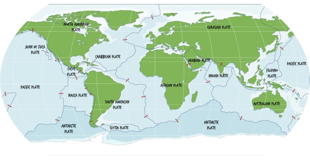
These smaller plates are often located in regions of intense seismic and volcanic activity, contributing to the complexity of the global tectonic system.
Plate boundaries do not respect political borders. They cross oceans, mountains, and densely populated areas, reminding us that geology operates on its own scale and logic.
The Ring of Fire: The Most Dramatic Stage of Tectonics
Along the margins of the Pacific Ocean stretches a vast horseshoe-shaped zone known as the Ring of Fire, one of the most geologically intense and fascinating regions on the planet.
This immense belt, encircling nearly the entire Pacific, is marked by a succession of deep ocean trenches, chains of active volcanoes, and seismic faults that reveal the ongoing force of plate tectonics. It is not merely a line of volcanoes—it is a dynamic system where oceanic crust is constantly being consumed, deformed, and renewed.
Most of this extreme activity results from the interaction between the Pacific Plate and the various plates surrounding it. In many areas, the Pacific oceanic plate sinks beneath continental or island plates along long subduction zones, generating deep earthquakes and explosive eruptions.
That is why about three-quarters of the world’s active volcanoes are concentrated in this region, along with most of the strongest earthquakes ever recorded.
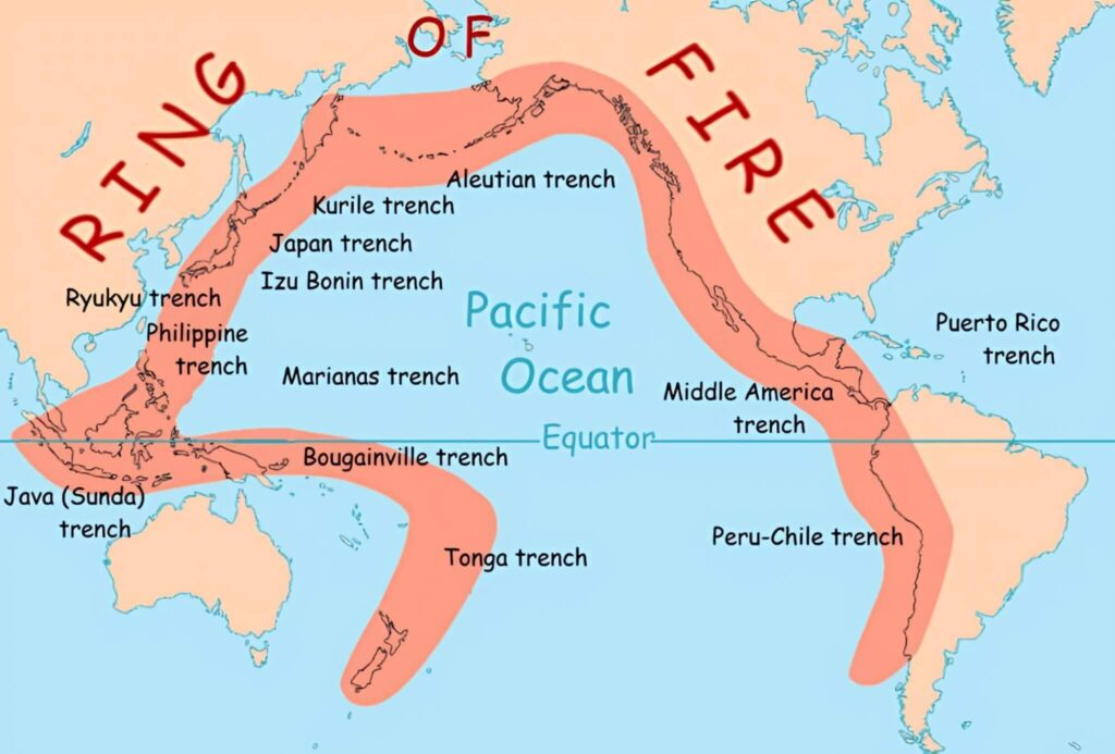
The Ring of Fire is not uniform; each segment has its own characteristics. In Japan, for example, the collision between the Pacific Plate and the North American Plate creates one of the most closely monitored seismic regions on Earth, where earthquakes and tsunamis are constant risks.
In Indonesia, interactions among several plates — including the Indo-Australian and Eurasian Plates — produce one of the most volcanic archipelagos in the world, with frequent eruptions that shape the landscape and influence the lives of millions.
Along the west coast of the Americas, the Ring of Fire manifests in equally dramatic ways. In Chile, the subduction of the Nazca Plate beneath the South American Plate generates some of the strongest earthquakes ever measured, while also feeding the extensive Andean volcanic arc.
In the United States, especially in California, the dynamics shift: transform faults dominate, such as the San Andreas Fault, where the Pacific and North American Plates slide laterally past each other, accumulating energy that is released in potentially devastating earthquakes.
This combination of subduction, collision, and lateral sliding makes the Ring of Fire a true natural laboratory for the study of tectonics, a region where Earth reveals its internal energy clearly and, at times, dramatically.
When Earth Acts: Historic Events
The movement of tectonic plates lies behind some of the most impactful natural disasters in recent history.
Earthquakes
- Tōhoku, Japan (2011) — subduction of the Pacific Plate generated a devastating tsunami.
- Chile (2010) — collision between the Nazca and South American Plates.
- Haiti (2010) — transform boundary between the Caribbean and North American Plates.
Volcanic Eruptions
- Mount St. Helens, USA (1980) — Its activity is linked to the subduction of the Juan de Fuca Plate beneath the North American Plate.
- Mount Pinatubo, Philippines (1991) — Its eruption was caused by the interaction of the Philippine Sea Plate, the Pacific Plate, and the Eurasian Plate along complex subduction zones in Southeast Asia.
- Indonesia — It lies along multiple convergent plate boundaries, particularly where the Indo-Australian Plate subducts beneath the Eurasian Plate, making it one of the most volcanically active regions on Earth.
These events demonstrate how Earth’s internal dynamics directly influence human life, requiring constant monitoring and prevention strategies.
How do we know all this? The science behind Tectonics
Identifying plate boundaries and understanding their movement result from decades of research and multiple lines of evidence:
Seismicity: Earthquakes align along plate boundaries.
Volcanism: Active volcanoes reveal subduction zones and mid-ocean ridges.
Oceanic magnetism: Symmetrical patterns record seafloor spreading.
GPS and satellites: Measure plate motion with millimeter precision.
Comparative geology: Similar fossils and rocks on distant continents indicate ancient connections.
Beyond revealing how Earth’s crust is organized, these scientific tools play a crucial role in protecting populations living in high-risk areas.
By monitoring seismic patterns, ground deformation, and plate movements, researchers can identify subtle changes that precede major geological events. Although it is still impossible to predict the exact timing of an earthquake, the combination of seismic, geodetic, and geological data allows scientists to recognize trends, estimate probabilities, and issue early warnings in some situations.
This set of technologies transforms the study of tectonics into a practical tool for prevention—helping save lives, guide public policy, and strengthen community resilience in the face of our planet’s inevitable and powerful motion.
Image source: nationalgeographic.org/society/